
Thru-Hiking the Chief Pontiac Trail, Pt. II: Proud Lake to Kensington
- Dan Cooke

- Jul 20, 2023
- 8 min read
Updated: Sep 17, 2024
Along the banks of the Huron River and through the towering pines of Proud Lake, we retraced the generational footsteps of one of the Detroit region's oldest backpacking routes: the Chief Pontiac Trail. Join us on this concluding Part 2 of this series that follows this classic Michigan hiking trail from Proud Lake to Kensington Metropark!
Pro tip: try to get more than 3 hours of recovery sleep in the middle of a ~20 mile thru-hike.
The key word there is "try." Two of our more recent Expedition Detroit articles have centered on the elusive concept of a restful night's sleep in the outdoors. On one end of the spectrum, you have hammock camping: your best bet for a glorious slumber while swaying ever so slightly under a starlit night. Perfect for pristine, solitary, and obviously forested nights in the Detroit region's natural environs.
On the other end - and I shudder as I begin to type these words - you have my mid-Chief Pontiac Trail camping set-up at Proud Lake's Modern Campground. Let us be clear, there's nothing inherently wrong with this particular campground. However, when your sole camping option along the trail involves reserving a spot at one of the most popular campgrounds in the entire Detroit area, well, you get what you signed up for. I detailed my night from hell in our aptly-named "Five Guaranteed Ways to Piss Off an Entire Campground" article, so I won't rehash that horror story here.
Here's the plain truth: pursuing an outdoor lifestyle, including the lifelong adventures and benefits that accompany it, often comes with the price tag of "Type 2 Fun." Anyone will gladly identify as an "outdoor enthusiast" when running on a full night's rest, perfect conditions, amazing company, and immaculately-curated trails. The crowd thins a bit when your exhausted body further suffers through a horrendous night, the rain clouds roll in, nature has reclaimed what once resembled a trail, and you're completely alone.
In those "Type 2" conditions, our advice is simply to live, laugh, and get your ass back on the trail. Fully embrace the terrible hand that your outdoor experience has dealt you. Why? Because the adventure doesn't start until something goes wrong, and nobody likes a story where everything went right.
Day 2 on the Chief Pontiac Trail started with this exact mindset. Three hours of tortured sleep. A torrential downpour rolling in. Exhausted legs. And ~8 miles to backpack.
Perfect variables for an unforgettable adventure. Let's get back to the trail.
CHIEF PONTIAC TRAIL: Proud Lake Modern Campground to Kensington Metropark
Total Distance: 7.83 miles
Elevation Gain: 387 feet
Trail Rating: Moderate
Route Orientation: Point-to-Point
Parking Specifics: Parking available at Proud Lake Recreation Area's Modern Campground (for overnight campers), Proud Lake's Huron River Fishing Site Parking Lot (for day hikers), and Kensington Metropark Group Camp Area; Michigan Recreation Passport and/or Metroparks Pass required.
Heading out from Proud Lake's Modern Campground, I had to immediately accept the fact that I would be flying blind from a trail mileage perspective. The route map displayed above - which I created specifically for this article - accurately tracks not only the current route of the marked Chief Pontiac Trail, but the total mileage from Proud Lake's far more popular campground. An outdated Chief Pontiac Trail route did exist on AllTrails, but that route omitted the initial 1.8 miles that I needed to trek just to arrive at the Pines Organizational Campground.
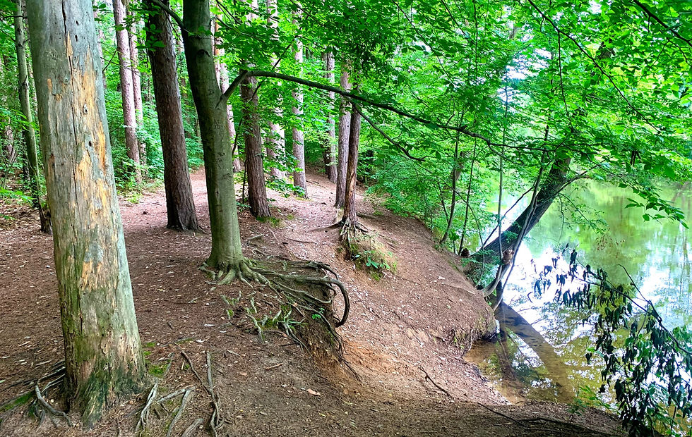
This may feel like back-tracking when compared to the conventional Boy Scouts route, but our "Expedition Detroit route" provides a far more panoramic view of Proud Lake State Recreation Area. The first 1.2 miles hiking west from the campground provide sweeping views of the hardwood forests and marshlands that define the southern banks of Proud Lake, Moss Lake, and the Huron River. Some of the long straightaway vistas lined with towering pine trees are genuinely breathtaking - we would even dare to say that these impressive trees qualify as the Detroit region's equivalent of California's redwoods.
Our point here is that this "extended cut" rendition of the conventional Chief Pontiac Trail route is stunningly beautiful. Plus we could all benefit from an extra mile or two, right?

After passing through Proud Lake's main trailhead parking lot at the 1.5 mile marker, continue trekking north to officially rejoin the marked Chief Pontiac Trail at Trail Marker #22. Don't get too comfortable, however; our route does almost immediately deviate from the marked route at the 1.7 mile marker.
Our rationale for doing so involves over a quarter mile of hiking right along one of the most idyllic stretches of the Huron River. You will pass through the Lower Pines Organizational Campground before heading due west to reach the Huron River Fishing Site. The fact that this 0.3 mile excursion isn't included on the conventional Chief Pontiac Trail might represent one of the most laughable screw-ups in the history of trail building...but we're more than happy to remedy this shortcoming for our readers.
EXPLORE THE BEST OF PROUD LAKE ALONG THE NEW EXPEDITION LOOP TRAIL!
The Fishing Site does contain picnic benches and portable toilets, so this provides a decent rest location before crossing Wixom Rd. into Proud Lake's remote western trails. We also strongly suggest reapplying bug spray at this point, especially if you may have neglected to apply when breaking down camp. The mosquito hordes anxiously wait your arrival.

Once safely across Wixom Rd. (please exercise extreme caution at this busy crossing), a prominent Chief Pontiac Trail sign will welcome you to roughly 4.4 miles of pristine parkland hiking. Starting in Proud Lake, the Chief Pontiac Trail bisects the park's primary equestrian and mountain biking trails in a consistently southwestern direction. The Boy Scouts and other volunteer groups have done a tremendous job maintaining the first 0.4 miles of this segment of the trail.
At the 2.5 mile marker, you will notice a moderate incline in the trail before cutting across a clear-cut portion of the trail. We flag this for your attention not because this segment poses any real difficulty, but as a warning. If you have any loose items, secure them. If you brought "water shoes" or sandals, you might want to change into them. If you brought a bush-whacking tool like a machete, you might want to unsheathe it.
Brace yourself - the marshes are coming.

The 0.2 miles of hiking between the Norton Creek Bridge and the Lake State Railway tracks is one of the most difficult patches of Detroit region hiking. Why? Well, starting with the wobbly bridge, this short section of the Chief Pontiac Trail guides you through a gauntlet of severely overgrown brush, eager thorns, flooded trail, legions of mosquitos, and no alternatives for reprieve. Trekking through the lowlands around Norton Creek genuinely constitutes an "expedition," so if you're looking to push your outdoor comfort zone in the Detroit area's outdoors, then this is the segment for you.
This segment is fortunately brief - the mud dissipates essentially right when any gradient resembling an incline starts to kick in. You will then sharply ascend towards the railroad tracks, cross directly over them (another crossing to exercise extreme caution at), and proceed west towards signs for Loop 4 and the Chief Pontiac Trail.

In the immortal words of Guns N' Roses, "Welcome to the Jungle." Starting at the 3.3 mile marker, you will trek through one of the wildest, most isolated segments of Proud Lake State Recreation Area. Insulated by thick brush far from the diligent chainsaws and brush hogs of the mountain biking and equestrian faithful, this hiking-only portion of the Chief Pontiac Trail feels more like the Amazon than the northwoods of the Great Lakes region.
This, friends, is a very good thing.
Well maintained trails are ideally suited for the masses, but here at Expedition Detroit, we don't want manicured, Disney World-styled trails. As cliché as this sounds, we want an adventure. We crave the feeling that we're rediscovering a long-lost route, especially when hiking in the heart of the Detroit region. Again, just pack in a machete for the nearly-impassable parts, and you'll have a genuine expedition on your hands along the Chief Pontiac Trail.
The "Great Climb" makes this rugged 1.3 mile stretch of the trail even more memorable. Especially after navigating through the jungle and crossing over Childs Lake Rd., you will reach both the southernmost and second highest (1,102 ft. elevation) point of the Chief Pontiac Trail at the 4.1 mile marker. You will reach this "Day 2 Peak" while trekking through a combination of steep rocky climbs and extended forested approaches, all the while criss-crossing through the freshly-established mountain biking and equestrian trails. This portion of the hike may get a little navigationally confusing due to the plethora of signage, but just remember to keep looking for the little orange arrowheads that point directionally towards the trail. Our map above should help too.

Old Plank Rd. represents a rite of passage in several respects. First, you will start the "Great Descent" that persists throughout the entirety of the "Proud Lake/Kensington Connector Trail" shared by mountain bikers, hikers, and trail runners alike. Second, you will pass into your third and final park of the Chief Pontiac Trail: Kensington Metropark.
The Connector Trail largely runs in an east-west direction, oscillating between sparsely wooded portions and open grasslands. The trail also includes a few mountain biking-intended features which add some variety to this otherwise simple stretch of the trail. Regardless, your legs will welcome the relatively consistent stretch of relaxed hiking.

The Connector Trail ends right at Milford Road. Yes, right across the street from the Dairy Queen, which is not the mirage of a calorie-depleted and/or sleep deprived mind. Only 1.3 miles of the Chief Pontiac Trail remain at this point, so we strongly encourage you to resist any ice cream impulses and use the DQ as an incentive to finish strong. Much easier said than done, we know.
Once across Milford Road, you will briefly follow the paved path before turning sharply north to follow the natural Chief Pontiac Trail route (look for the metallic trail sign). Despite spending the majority of the last four years in Milford - and biking/running the paved Milford Trail countless times - I had never hiked this natural trail before.
Ladies and gentlemen, this final segment of the Chief Pontiac Trail may be its most memorable. Rolling, open hills. Wildflowers in full bloom. Sweeping vistas over the northern stretches of Kensington Metropark, coupled with rugged, overgrown sections along surprisingly steep ridge lines. Yes, there are portions that link back up with the paved Milford Trail, but the approach to Kensington's Group Camp area represents one of the most scenic surprises that I've had the pleasure to encounter while exploring the Detroit region.
The Grand Finale: Crossing the Group Camp Road Bridge over the Huron River
Spoiler alert: if you're looking for a grand finale to the Chief Pontiac Trail - something to the tune of the sign at Mt. Katahdin's peak for the Appalachian Trail or the monuments for the Pacific Coast Trail - you're not going to find one. While the origination point for the Chief Pontiac Trail in Highland Recreation Area is well marked via a photo-worthy sign, there's nothing similar in Kensington. I even hiked around for a bit looking for the official terminus. Nothing.
Eventually I said "screw it," pulled out my phone while standing on the Group Camp Road Bridge, and Google searched for the exact point that the Chief Pontiac Program defines as the trail's "official terminus."
Naturally, I was standing right on it.
"The official trail end is on the bridge to the west. This has been a tradition since the trail's inception in 1958. Literally thousands have completed their trek by ceremoniously walking onto the bridge. Here is the place and time to congratulate each other and take pictures."
And just like that, the inaugural Expedition Detroit thru-hike of the Chief Pontiac Trail was complete. An adventurous, solitary, exhausting, exhilarating, beautiful, and storied rite of passage that generations of outdoor enthusiasts have completed for nearly 70 years. A trail with the utmost potential for preservation, expansion, and collaboration among stakeholders in the Milford area.
In other words, just a damn good trail.
We'd like to offer a special thank you to Blue Birch Outfitters for addressing our gear needs and outfitting us with a brand new Osprey backpack for this adventure! Hitting the trail with the right gear can truly make or break an outdoor experience. With Blue Birch's convenient location in the heart of Downtown Milford, you can explore the vast majority of the Detroit region's outdoor destinations knowing that there's a fully-stocked retailer just around the corner.


Comments