
Welcome back to our #TrailTuesday Series! This edition explores the backcountry of the Detroit region's least known Michigan State Park: Ortonville State Recreation Area. Join us as we scale the heights and navigate the backwoods of Ortonville's Kerr Hill and Four Lakes Loops Trail!

Yeah...I get it now.
That little quip holds a special place with my hiking crew. Credit's owed to my buddy Joe, who originated it during his first backpacking trip with us back in February of 2021. We had finally arrived in Canyonlands National Park, just in time for a cowboy-cliché sunset from the park's Green River Overlook. Silence overtook the group as we were entranced by the panoramic view below us.
Silence only to be broken by Joe's line. Followed by an eruption of laughter from all of us.
Nearly four years later, this line is reserved for outdoor moments when awestruck by a natural phenomenon. Especially when said phenomenon surpasses all expectations of its grandeur, despite ample literature that clearly foretells of its legitimacy.
Exhibit A, the Grand Canyon. For some indefensible reason, I fully expected it to be "not-as-grand" as its same suggests. Too much publicity, too many visitors - has to be underwhelming, right?
Wrong. Dead wrong. To this day it is truly one of the most impressive, awe-inspiring natural phenomenons that I have ever seen.
We at Expedition Detroit believe that the entire Detroit region belongs in the "Yeah...I get it now" genre of outdoor destinations. We have experienced this firsthand on our guided trips, witnessing guest after guest fall in love with the forests, lakes, hills, and wildlife that define our corner of the world. Most of whom have lived in the Metro Detroit for their entire lives, yet never thought they would or could encounter such natural beauty in their own backyard.
The best part of this gig is that I get to actively seek out those "Yeah...I get it now" destinations for this community. The "Parks Unknown" of the Detroit region that have miraculously, and tragically, escaped the attention of the wider outdoor world.
This investigative appetite led me to the outer fringe of the Detroit region in Lapeer County, summiting one of its tallest moraines, in the midst of the least-visited Michigan State Park in all of Southeast Michigan. All by myself on a bluebird winter's day. Surrounded only by beautifully-rolling hills, forests, and shimmering lakes.
Yeah... hopefully you're starting to get it now, too. It's our pleasure to introduce Ortonville State Recreation Area and the Kerr Hill and Four Lakes Loop Trail to this platform.

MEET ORTONVILLE STATE RECREATION AREA
Ortonville State Recreation Area has held several names in its century+ history. Although technically founded in 1944 like so many other Detroit region State Parks and Recreation Areas, the 5,400 acres now comprising the park started with the southernmost quadrant of 46 acres. This segment was originally known as "Bloomer #3 State Park" after its 1922 donation from public lands-pioneer Howard Bloomer.
Locals subsequently bestowed the name "Hadley Hills" to the westernmost region of the park. Utilized largely for equestrian, fishing, and snowmobiling recreation, the Hadley Hills provides a renown destination for horseback and snowmobile riding due largely to its diverse, rugged moraine terrain. All trails in the Hills lead to Pinnacle Point, a ridge top climbing to 1,100 ft. that once contained a lookout hut at its peak (ruins still remain).
For this article's purposes, we're most interested with the least visited eastern segment of Ortonville Rec: Kerr Hill. This section of the park was named after 19th century pioneer Robert Kerr, who farmed the land located on both sides of Hadley Road near where Fox Lake Road crosses Hadley Road. South Hadley Cemetery is also located there, thus answering why Kerr Hill is often cross-referenced as "Cemetery Hill." Its forested hilltop constitutes the second-tallest point in Lapeer County (first is privately-owned), standing proudly at 1,229 feet.
The Ortonville Recreation Area of 2025 that covers all 3 of the segments provides a lifetime of outdoor recreation opportunities for thrill-seeking visitors. The park has established itself as a "hidden gem" destination not only for equestrians and snowmobilers, but also mountain bikers, cross-country skiers, hunters, anglers, paddlers - and, of course, hikers.
For adventure-seekers truly looking to experience one of the Detroit region's most scenic, intrepid, and surprisingly rigorous trails, there few - if any - better than Ortonville's Kerr Hill and Four Lakes Loops Trail.
Let's get to the trail.
HIT THE TRAIL
Total Distance: 4.7 miles
Elevation Gain: 614 feet
Trail Rating: Moderate
Route Orientation: Loop
Parking Specifics: Limited parking available at Road Lake trailhead (located off of Fox Lake Road)
The origination point of the Kerr Hill and Four Lakes Loop Trail represents one of the strangest hiking experiences for any outdoorist. A typical trail to a high point usually begins at the lowest point of the trek, gradually builds to a scenic overlook, and then rewards your efforts with a steady, relaxing decline back to the trailhead.
Not so for Kerr Hill. The trek starts at nearly the highest elevation of the entire trail, leading to a deceptively-easy "summit" of the trail's namesake hill. The true summit is located within the woods off to your right as your ascent starts to flatten out. Attention Peak Baggers - please remember "Leave No Trace" principles as you venture out to conquer the Kerr Hill Summit.
"Ah, I get it now." You'll be tempted to orate that phrase a few times as you start you descent into the massive, forested valley due east of the summit. After reaching the summit just 0.1 miles into the trail, the next 0.4 miles of hiking comprises a straight, dramatic descent into the heart of Ortonville State Recreation Area's "Four Lakes" wilderness region. The descent is steep for the Detroit region's trails, including 12% declines in certain rocky, root-filled sections. Enjoy the views; descend with caution.
Your descent will end along the banks of Round Lake, the first of four sizeable lakes that the route features. If you choose to pack in an inflatable kayak or paddleboard during the warmer months, Round Lake will be your best option for a relaxed, scenic float. Also an ideal spot for cracking a few trail beers for your day on the water (always consume responsibly).

From Round Lake, the Kerr Hill and Four Lakes Loops Trail backtracks 0.3 miles before continuing southwest into the heart of the park. The trail provides you with a sneak-peek into your hiking future at the 0.7 mile marker - a preview of the trail's final ascent back up to Kerr Hill 4 miles later. Fair warning, it's steep. But that's why you're here, conquering one of the highest points in the entire Jackson Interlobate Range.
Regardless, that's a challenge for a future iteration of you. Keep hiking downhill into the heart of the valley. Once at the valley floor, you'll gradually start to ascend again before reaching a trail intersection at the 1 mile marker. Look for a pink paint marker on a tree at the intersection (depicted below).
The AllTrails route will direct you south at this point. Team Expedition Detroit decided to complete the route in a scenic clockwise direction.
This article will follow our traverse of the Kerr Hill and Four Lakes Loops Trail. Obviously.

From the "pink tree intersection," the trail leads 0.6 miles along a notable moraine ridge line towards isolated Mud Lake. This area is very popular with hunters during open seasons, so please be mindful of any hunting activity during peak morning and evening shooting hours while in-season.
Similar to Round Lake, the Mud Lake section of the Kerr Hill and Four Lakes Loops Trail provides hikers with an opportunity to trek right up to the shoreline. The isolated nature of Mud Lake means that it provides an ideal bird watching, wildlife viewing, and fishing destination. Also an idyllic spot to enjoy any snacks that you may have packed in.
After completing another ascending backtrack of 0.4 miles, keep left at the Diehl Road parking area to continue along the two-track road for 0.1 miles. Turn east (left) at the first opportunity to stay on the trail towards Davison Lake.

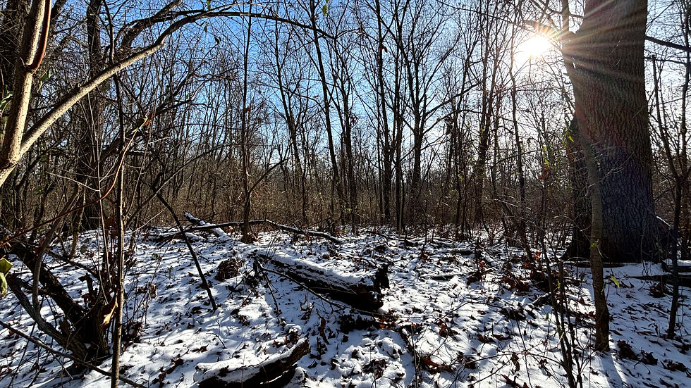
In our humble opinion, the next 0.7 miles of trekking proved to be some of the most difficult terrain that we've encountered throughout the Detroit region. Why? Simply due to the scant, if completely nonexistent, trail maintenance that we encountered while hiking through the isolated eastern section of the Kerr Hill and Four Lakes Loops Trail.
That's not to say that we didn't enjoy this segment of the trail. To the contrary, it was one of our favorite aspects of the entire experience. In an age where so many outdoor spaces have been pacified into sanitized, paved, and "dummy-proof" experiences - especially in greater metropolitan regions - discovering an authentically intrepid trail is worth celebrating. If nothing else, the Kerr Hill and Four Lakes Loops Trail provides an opportunity to test your orienteering and resiliency within a manageable recreational arena.
There are several moments during this segment of the trail where the trail appears to disappear into thin air. Trust us, it's there. But your eyes and mind may beg to differ.

Here are some signs to look for if you find yourself unsure regarding whether you're still on the Kerr Hill and Four Lakes Loops Trail - or any trail for that matter:
Stop: Pause for a moment, calm your breathing down to 3 second inhales/exhales, and assess your surroundings. Stay calm, stay put. Panic is your greatest enemy.
Think: Go over in your mind how you got to where you are. What landmarks should you be able to see vis-à-vis the AllTrails map? Do not move at all until you have a specific reason to take a step.
Observe: Look for any signs of the trail that you were surely following just moments prior. Other key indicators include boot prints in snow or mud, trampled grass or vegetation, and tree clearings. As a very last resort, follow a drainage or stream downhill. This is often a difficult path but could lead to a trail or road. Again, this could be very dangerous.
Plan: Based on your thinking and observations, come up with some possible plans, think them through, and then act decisively on one of them. If you are not very, very confident in the route, then it’s always better to stay put. If it’s nightfall, you are injured. or you are nearing exhaustion, stay in place and seek shelter.
As you may have noticed, the four steps noted above form an acronym: "STOP." The outdoor recreation industry absolutely loves acronyms, but this one is easily to most useful since it also forms the first action step for assessing your situation.
For us, we STOPped several times during this stretch of the trail. Boot prints and broken vegetation were our best friends. Just remember to keep calm, reference your map as needed, and relish the opportunity to live a genuine wilderness experience in Metro Detroit.

As you complete the 1.4 mile "semi-loop" through the heart of the Kerr Hill and Four Lakes Loops Trail's southernmost region, you'll be treated to scenic - yet distant - views of Davison Lake and Big Fish Lake. The Davison Lake vista on a clear winter's day is especially beautiful and provides yet another reason to visit this rarely-visited park during its "offseason." The rolling terrain and open woodlands leading back to the "pink tree intersection" provide welcomed variety as well.
The last half-mile of the Kerr Hill and Four Lakes Loops Trail provides déjà vu, but with a twist. Yes, you will undoubtedly recognize the "valley" as you descend back into it. What will seem surprising, however, is the climb. The half-mile, 17% incline, consistent climb straight up Kerr Hill.
Remember that sneak-peek from earlier? Future you's challenge?
Guess what. It's go time.
As the porters say all along the slopes of Mt. Kilimanjaro, take this final stretch "Pole Pole." That phrase is Swahili for "Slowly Slowly," encouraging trekkers to slow down and although their bodies to adjust to the extreme altitude.
Here you will not be ascending to over 19,000 feet. But you will be facing your steepest challenge of the day, at the very end of moderately challenging hike, within earshot of the parking lot. Those variables - terrain difficulty, exhaustion, and a decreased caution due to trailhead proximity - are often a recipe for disaster.
Pole Pole, friends. Complete the summit to Big Fish Road. Follow the road uphill to the trailhead. Head home with the innate satisfaction of completing one of the most unique trail experiences to be found within Southeast Michigan.
The #TrailTuesday Series idea started as a recommendation from readers looking for a deeper analysis into the individual trails that define Detroit's vast network. One of our main goals for this platform is to produce content that reflects the outdoor interests and desires of our community, so please continue to provide us with your suggestions via our contact form or here in the comments!
Comments